How it works
GPS satellites circle the earth twice a day in a very precise orbit and transmit signal information to earth. GPS receivers take this information and use triangulation to calculate the user's exact location. Essentially, the GPS receiver compares the time a signal was transmitted by a satellite with the time it was received. The time difference tells the GPS receiver how far away the satellite is. Now, with distance measurements from a few more satellites, the receiver can determine the user's position and display it on the unit's electronic map.
A GPS receiver must be locked on to the signal of at least three satellites to calculate a 2D position (latitude and longitude) and track movement. With four or more satellites in view, the receiver can determine the user's 3D position (latitude, longitude and altitude). Once the user's position has been determined, the GPS unit can calculate other information, such as speed, bearing, track, trip distance, distance to destination, sunrise and sunset time and more.
The Parts of GPS
GPS consists of three main segments:
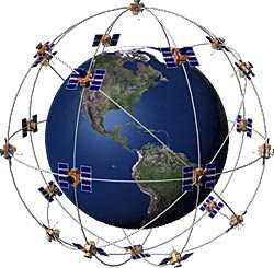
The Space Segment: This part consists of 24 satellites, manufactured by Rockwell International, which are launched into space by rockets, from Cape Canaveral, Florida. They are about the size of a car, and weigh about 19,000lbs. Each satellite is in orbit above the earth at an altitude of 11,000 nautical miles (12,660 miles), and takes 12 hours to orbit one time. There are 6 orbital planes each having 4 satellites. The orbits are tilted to the equator of the earth by 55° so that there is coverage of the polar regions. The satellites continuously orient themselves to ensure that their solar panels stay pointed towards the sun, and their antennas point toward the earth. Each satellite carries 4 atomic clocks.
The Control Segment: This part consists of 5 worldwide unmanned base-stations that monitor the satellites to track their exact position in space, and to make sure that they are operating correctly. The stations constantly monitor the orbits of the satellites and use very precise radar to check altitude, position and speed. Transmitted to the satellites are ephemeris constants and clock adjustments. The satellites in turn, use these updates in the signals that they send to GPS receivers.
The User Segment: This part consists of user receivers which are hand-held or, can be placed in a vehicle. All GPS receivers have an almanac programmed into their computer, which tells them where each satellite is at any given moment. The GPS receivers detect, decode and process the signals received from the satellites. The receiver is usually used in conjunction with computer software to output the information to the user in the form of a map. As the user does not have to communicate with the satellite there can be unlimited users at one time.How GPS Works
The basic principle behind GPS is the measurement of distance between satellites and the receiver. The distance to at least 3 satellites must be known in order to find out a position. Satellites and receivers generate duplicate radio signals at exactly the same time. As satellite signals travel at the speed of light (186,000 miles per second), they take a few hundredths of a second to reach the GPS receiver. This difference and the speed at which signal travels is used in the equation to find out the distance between the GPS receiver and the satellite.
Speed x Time = Distance
So, if it takes 0.09 of a second for a satellite's signal to reach the GPS receiver, the distance between the two must be 16,740 miles (186,000 miles per second x 0.09 seconds = 16,740 miles). The GPS receiver must be located somewhere on an imaginary sphere that has a radius of 16,740 miles.
If it takes 0.08 seconds for the signal to reach the GPS receiver from a second satellite then the receiver must be located somewhere on an imaginary sphere that has a radius of 14,880 miles, and where the two spheres intersect.
Supposing it takes 0.07 seconds for the receiver to receive a signal from a third satellite then the GPS must be located somewhere on a sphere that has a radius of 13,020 miles and where the three satellites intersect.
Not only do the satellite signals contain data that the GPS receiver uses to calculate distance, but data that enables the receiver to make adjustments needed to get an accurate position. Atmospheric data is sent in the signal as the receiver has to account for delays in the time it takes for the signal to reach it. These decreases in the speed of the signal are caused by the ionosphere and the troposphere.This information is usually used in conjunction with software on a laptop or PDA (Personal Digital Assistant) in the form of a map, to show the GPS receiver user their location.
(form garmin and radioshack website)